My Town Legal colleague Tom Brooks provided a mark up of the changes from the previous guidance. They are as follows:
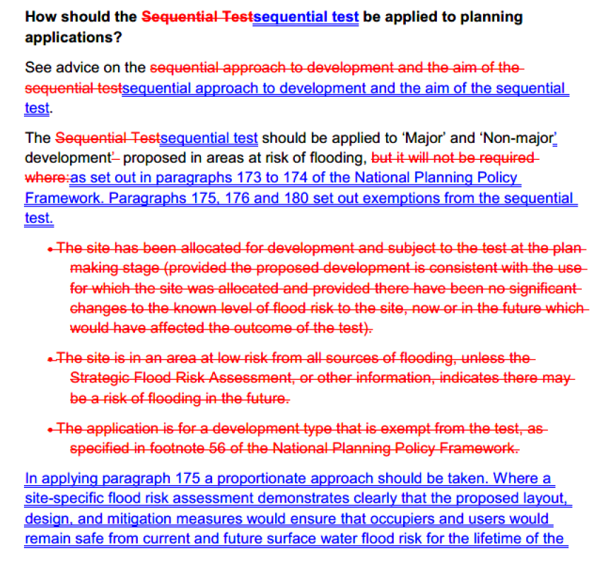
The important change is that we move from a position where the sequential approach is still required where the site is currently at risk of flooding, even where that risk would be removed as a result of development, to a position where it is not required as long as “a site-specific flood risk assessment demonstrates clearly that the proposed layout, design, and mitigation measures would ensure that occupiers and users would remain safe from current and future surface water flood risk for the lifetime of the development (therefore addressing the risks identified e.g. by Environment Agency flood risk mapping), without increasing flood risk elsewhere.” So, if your flood risk consultant is in a position to reach such a conclusion, no longer does there need to be a wide trawl for other sites, currently at lower risk of flooding, where the development might be situated. Might developers still hedge their bets and engage in a sequential testing just in case an issue arises? I suspect so, but this change is certainly going to simplify applicants’ case as to flood risk matters in many instances – particularly, I suspect, where the only potential risk arising is by way of the accumulation on site of surface water.
Whilst not stated in the revised guidance, I note that disapplication of the need to follow the sequential approach also has the effect of relieving developers as well from complying with the two limbs of the “exception test” that have to be followed once the sequential approach has been navigated:
“a) the development would provide wider sustainability benefits to the community that outweigh the flood risk; and
b) the development will be safe for its lifetime taking account of the vulnerability of its users, without increasing flood risk elsewhere, and, where possible, will reduce flood risk overall.“
The reference in the revised guidance to the fact that, if a sequential approach is followed, housing considerations, including housing supply, should be weighed in the balance against the outcome of that process, is helpful express recognition of the approach already taken by various appeal inspectors (see again my July blog post): planning permission may still be granted even if the test is failed – if there are sufficient weighty counterveiling considerations.
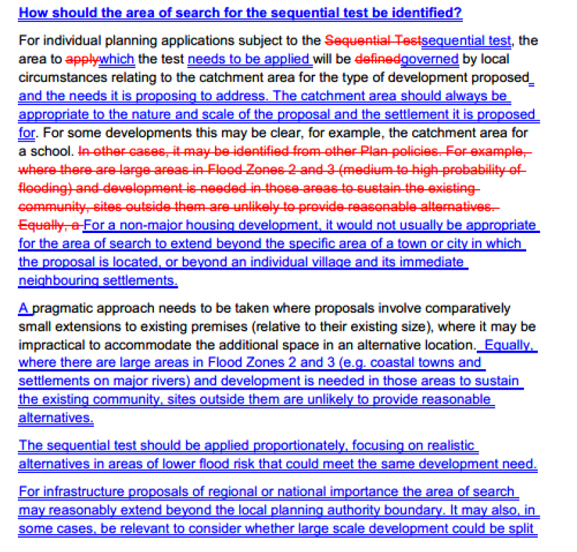
The other amendments to the guidance give further clarity to the parameters of the search for alternative sites to be carried out under the sequential approach:
As with MHCLG’s February 2025 planning practice guidance on grey belt, at a time where the need to simplify and rationalise our current sprawling system is so acute and urgent, isn’t it interesting how pragmatic changes can still be be made without recourse to legislation or indeed even lengthy consultation processes?
It’s finally raining properly this morning. What else could I write about…?
The government’s general advice is that planning permission shouldn’t be granted for development in flood risk areas without an assessment first being carried out as to whether the development could be accommodated in a lower risk area. Fair enough, but a change to the government’s planning practice guidance in 2022 for the first time expressly extended this advice to “areas at risk of surface water flooding“, rather than just areas at risk of flooding from rivers or the sea.
The December 2024 version of the NPPF didn’t resolve the problem but at least alleviated it with the emboldened passage:
“170. Inappropriate development in areas at risk of flooding should be avoided by directing development away from areas at highest risk (whether existing or future). Where development is necessary in such areas, the development should be made safe for its lifetime without increasing flood risk elsewhere.”
“172. All plans should apply a sequential, risk-based approach to the location of development – taking into account all sources of flood risk and the current and future impacts of climate change – so as to avoid, where possible, flood risk to people and property. […]
“173. A sequential risk-based approach should also be taken to individual applications in areas known to be at risk now or in future from any form of flooding, by following the steps set out below.
174. Within this context the aim of the sequential test is to steer new development to areas with the lowest risk of flooding from any source. Development should not be allocated or permitted if there are reasonably available sites appropriate for the proposed development in areas with a lower risk of flooding. The strategic flood risk assessment will provide the basis for applying this test.
175. The sequential test should be used in areas known to be at risk now or in the future from any form of flooding, except in situations where a site-specific flood risk assessment demonstrates that no built development within the site boundary, including access or escape routes, land raising or other potentially vulnerable elements, would be located on an area that would be at risk of flooding from any source, now and in the future (having regard to potential changes in flood risk).”
The problem is that we are still currently left with the specific reference in the PPG to the need for a sequential test in relation to areas at risk of surface water flooding (the passage I have emboldened) (and Mead Realisations v Secretary of State (Court of Appeal, 30 January 2025) of course tells us that there is no “legal principle that prevents national policy in the NPPF being amended, or altered, by guidance in the PPG.”):
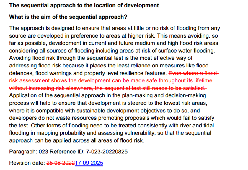
“What is the aim of the sequential approach?
The approach is designed to ensure that areas at little or no risk of flooding from any source are developed in preference to areas at higher risk. This means avoiding, so far as possible, development in current and future medium and high flood risk areas considering all sources of flooding including areas at risk of surface water flooding. Avoiding flood risk through the sequential test is the most effective way of addressing flood risk because it places the least reliance on measures like flood defences, flood warnings and property level resilience features. Even where a flood risk assessment shows the development can be made safe throughout its lifetime without increasing risk elsewhere, the sequential test still needs to be satisfied. Application of the sequential approach in the plan-making and decision-making process will help to ensure that development is steered to the lowest risk areas, where it is compatible with sustainable development objectives to do so, and developers do not waste resources promoting proposals which would fail to satisfy the test. Other forms of flooding need to be treated consistently with river and tidal flooding in mapping probability and assessing vulnerability, so that the sequential approach can be applied across all areas of flood risk.
Paragraph: 023 Reference ID: 7-023-20220825
Revision date: 25 08 2022”
The Government had indicated in its 12 December 2024 response to the revised NPPF consultation process that it would “shortly be updating planning practice guidance to clarify the definition of reasonably available sites that should be considered as part of the sequential test”. We still wait for that updated guidance and in particular to see if it will address this particular difficulty over surface water flood risk. Paul’s blog post explains well the nonsense of, and work and cost involved in, carrying out a sequential test looking for sites at lower risk of surface water flooding.
Pending any amended guidance, there have at least recently been some pragmatic appeal decisions by inspectors, most recently:
Ham Road, Faversham, Kent (27 June 2025) This is summarised by Zack Simons KC in his 4 July 2025 blog post Floods, puddles and “strong” refusals (which also references two other recent decisions: Yatton (albeit that this is subject to legal challenge) and HMP Garth and Wymott, Lancashire. The Faversham inspector was faced with an appeal where no sequential test had been carried out despite the site being at risk of both flooding from the sea and by way of surface water. “The proposal includes changing the land levels, including raising them in some areas, with the result that all areas of proposed built development would be some 300mm above the design flood level, ie would not be at risk of flooding. This could be secured by conditions(s).”
“The extent of pluvial flooding risk is relatively limited. It is from ponding on the site in existing depressions and similar factors. The depth of the flooding would be relatively shallow. There is no risk related to interrupting an off-site surface water flow path, or effects on other off-site properties. It is a fairly typical existing situation on an agricultural field. As part of the design detail for the proposal at reserved matters stages, the precise land levels, drainage solutions, and landscaping would all need to be considered. Given the limited nature of the existing and future surface water flood risk, designing out the flood risk could be comfortably accommodated as part of this natural detailed design process.
Overall, therefore, there is no real world harm from either the failure to undertake a sequential test for tidal flooding or the failure to properly undertake a sequential approach. This is because it has been satisfactorily demonstrated that mitigation measures can make the proposed development safe for its lifetime from tidal flooding. There are also reasons other than flooding that result, although likely only in part, in the land levels changing mitigation measures. There would also be no real world surface water flood risk to the finished and occupied development proposal.”
Nor was the failure to carry out the sequential test a “strong reason for refusal” such as to disapply the tilted balance in favour of granting permission (which applied due to the local authority’s poor housing land supply position).
Appeal allowed.
Sherwood Cross, Feniton (11 July 2025). Here, the site is “conducive to overland water flow in high rainfall events”. Water attenuation is proposed to the north of the site to protect the development site but also to provide overall betterment, the details of the proposed attenuation scheme to be the subject of a Grampian condition.
“The Sequential Test undertaken by the Appellant has not considered potential housing sites in the wider local authority area, as identified by the Council. That is on the basis of the Appellant’s claimed position that the proposal would uniquely include flood alleviation measures that would significantly lessen the flood risk off- site within that part of Feniton to the south of the site along Colestocks Road and further to the south, and that there are no other sites that could provide such benefits to Feniton. However, whilst the flood mitigation measures are an element of the proposal, as previously referred to, the northern attenuation areas have a dual function including to protect the proposed development from any flood risk.
The proposal is therefore fundamentally a housing scheme with attenuation measures necessary, in the absence of any other proposed mitigation, to protect it from flood risk, which would also take the opportunity to provide betterment to off- site flood risk. There is no substantive evidence to indicate that the various other potential sites for housing put forward by the Council would be unsuitable or not have a lower risk of flooding. As such, I have no substantive basis to find that there are no reasonably available sites appropriate for the proposed development in areas with a lower risk of flooding. The proposed development therefore fails the sequential test, in conflict with the Framework in this respect.”
However, the inspector goes on to conclude:
“I have also found that, in respect of flood risk, the proposal fails the sequential test and does not fully accord with policy EN22 of the Local Plan and F1 of the NP, having regard also to the absence of an agreed surface water outfall. However, I have also found that there would be likely betterment relating to off-site flood risk resulting from the proposals, in the context of the proposals making the development safe without increasing flood risk elsewhere. That would be subject to compliance with a Grampian condition to secure acceptable surface waterdrainage, which I have found would be appropriate in the circumstances of this case. Those factors therefore lessen the weight afforded to the above failures relating to the sequential test and development plan policy.”
Appeal allowed.
This pragmatism is all well and good but to assume pragmatism on the part of all decision-makers in the planning system is a mug’s game. Which is why we just need some clear guidance: of course if there is no certainty that any unacceptable risks arising cannot robustly be mitigated, surface water flood risk can and should be the basis for refusal of a planning application, but the sequential test should only be required in the case of sites at risk from flooding from rivers or the sea.
(from The Rime of the Ancient Mariner, by Samuel Taylor Coleridge, 1834)
But that’s all I’m going to say about MIPIM. This post is just a toe dip into (1) flood risk and (2) water scarcity.
Water Water Everywhere
Government policy on planning and flood risk is set out in paragraphs 165 to 175 of the current December 2023 version of the NPPF, supplemented by Government’s Planning Practice Guidance on flood risk and coastal change. The Environment Agency is the Government’s statutory planning consultee on flood risk issues.
The proper interpretation of the Government’s policy on flood risk, and in particular on the risk-based sequential approach to locating development which is at the heart of it, was considered in two recent cases. In relation to each of them I am simply going to point to the relevant Town Library summary (to subscribe for free to our weekly case law and other summaries click here ).
My colleague Jack Curnow summarised this case here. This was a legal challenge to two development consent orders for the construction of the East Anglia ONE North and East Anglia TWO Offshore Wind Farms together with associated onshore and offshore development. The environmental statement for the project dealt with flooding from surface water stated that the onshore substations and National Grid Infrastructure were located in areas primarily at low risk of surface water flooding, with some permanent infrastructure (parts of access roads) likely to cross areas at both high risk and medium risk of surface water flooding, with appropriate mitigation measures within the design to address any remaining surface water flood risk concerns. The court held that the sequential approach does not apply to the risk of flooding from surface water, as opposed to the risk of fluvial flooding. Whilst the risk of flooding from surface water is to be taken into account when deciding whether to grant development consent, that is a matter of planning judgment for the decision maker.
My colleague Chatura Saravanan summarised this case here. This case dealt with two challenges to inspectors’ decision letters:
a) a decision to dismiss the appeal by Mead Realisations Limited against the refusal by North Somerset Council for a residential development of up to 75 dwellings; and
b) a decision to dismiss the appeal by Redrow Homes Limited against the refusal by Hertsmere Borough Council for a residential development of up to 310 units and other facilities.
The claims were heard together as they raised the common central issue of what is the correct interpretation and application of the flood risk sequential test. Specifically, Mead and Redrow argued that the Inspectors misinterpreted paragraph 162 (now 168) of the NPPF in identifying what might be “reasonably available” sites under the sequential approach, in that they applied the guidance in paragraph 028 of the PPG, which conflicted with paragraph 162 of the NPPF. This raised the question of whether the PPG did indeed conflict with the NPPF and, if so, whether the NPPF should supersede the PPG.
Holgate J held that there was no rule that the PPG could not be inconsistent with the NPPF:
“As a matter of policy, PPG is intended to support the NPPF. Ordinarily, therefore, it is to be expected that the interpretation and application of PPG will be compatible with the NPPF. However, I see no legal justification for the suggestion that the Secretary of State cannot adopt PPG which amends, or is inconsistent with, the NPPF”.
However he held that in any event there was no conflict in any event:
“The PPG performs the legitimate role of elucidating the open-textured policy in the NPPF. The PPG describes “reasonably available sites” as sites “in a suitable location for the type of development with a reasonable prospect that the site is available to be developed at the point in time envisaged for the development.” The PPG provides for issues as to suitability of location, development type, and temporal availability to be assessed by the decision-maker as a matter of judgment in accordance with the principles set out above. In this context, the PPG correctly states that “lower-risk sites” do not need to be owned by the applicant to be considered “reasonably available.” That is consistent with the need for flexibility on all sides.”
For a number of more detailed arguments raised by the claimants (and all rejected), it’s worth reading the case itself or Chatura’s summary.
Nor Any Drop To Drink
Water scarcity is becoming one of those worrying “neutrality” issues which can cut across the more familiar uncertainties of the planning system – see the ongoing issues in Sussex referred to in my 9 October 2021 blog post Development Embargos: Nitrate, Phosphate & Now Water .
Another area where water scarcity concerns have been raised is of course Cambridge (where Samuel Taylor Coleridge was an undergraduate at Jesus College between 1791 and 1794 – these blog posts aren’t just thrown together). The Secretary of State’s 24 July 2023 long-term plan for housing committed to “transformational change” in Cambridge:
“Proposals will see Cambridge supercharged as Europe’s science capital, addressing constraints that have left the city with some of the most expensive property markets outside London, and companies fighting over extremely limited lab space and commercial property with prices that rival London, Paris and Amsterdam.
These ambitious plans to support Cambridge include a vision for a new quarter of well-designed, sustainable and beautiful neighbourhoods for people to live in, work and study. A quarter with space for cutting-edge laboratories, commercial developments fully adapted to climate change and that is green, with life science facilities encircled by country parkland and woodland accessible to all who live in Cambridge.
Any development of this scale will have substantial infrastructure requirements. The government will deliver as much of the infrastructure and affordable housing as possible using land value capture – with the local area benefiting from the significant increase in land values that can occur when agricultural land is permitted for residential and commercial development. Land values will reflect the substantial contributions required to unlock the development (see annex).
A Cambridge Delivery Group, chaired by Peter Freeman and backed by £5 million, will be established to begin driving forward this project. The Group will work to turn this vision into a reality, taking a lead on identifying the housing, infrastructure, services and green space required. It will also consider options for an appropriate delivery mechanism that will be needed to lead the long-term work on planning, land acquisition and engagement with developers, starting in this Parliament but running through the next few years as development takes shape.”
The Delivery Group was to “take forward immediate action to address barriers such as water scarcity across the city, including:
Convening a Water Scarcity Working Group with the Environment Agency, Ofwat, central and local government and innovators across industries to identify and accelerate plans to address water constraints. The Group will include all relevant partners to understand what it would take to accelerate building the proposed new Fens Reservoir and enabling Cambridge to reach its economic potential.
Supporting the council in efforts to make sure new developments proposed as part of the local plan can be as sustainable as possible, including whether new houses in planned developments such as Waterbeach and Hartree can be made more water efficient. To support this, the government is announcing today a £3 million funding pot to help support measures to improve the water efficiency of existing homes and commercial property across Cambridge, to help offset demands created by new developments in the local plan.
The government will also take definitive action to unblock development where it has stalled, providing £500,000 of funding to assist with planning capacity. Cambridge City Council, Anglian Water, Land Securities PLC and Homes England will work together to accelerate the relocation of water treatment works in Northeast Cambridge (subject to planning permission), unlocking an entire new City quarter – delivering approaching 6,000 sustainable well-designed homes in thriving neighbourhoods – as well as schools, parks and over 1 million square feet of much needed commercial life science research space.”
“Our first priority is water scarcity, which is holding back development and risks causing environmental harm. It is vital that the city has the water supply it needs to support long-term growth, including a new reservoir in the Fens and a new pipeline to transfer water from nearby Grafham Water. We are also making a one-off intervention to support growth in the shorter-term by delivering water savings through improved water efficiency of appliances in existing buildings that can offset new homes and commercial space.
The government will:
Deliver a unique offsetting intervention to save water now through improving efficiency and support sustainable growth – set out in detail in a paper published alongside this document.
Issue a joint statement from the Environment Agency, Greater Cambridge Shared Planning, DLUHC and Defra, outlining our commitment to sustainable growth and development on the basis of our water credits scheme.
Appoint Dr Paul Leinster to chair the Water Scarcity Group to advise the government on future water resource options, including the reservoir in the Fens and the Grafham Water pipeline.”
Alongside the case for Cambridge document, a joint statement between DLUHC, Defra, the Environment Agency and Greater Cambridge councils (Cambridge City and South Cambridgeshire districts) on measures to address water scarcity issues in the area was published on the same day, setting out its proposed scheme to develop, and help to fund, a water credits market “intended to provide greater certainty through:
a. The delivery of water savings measures in the Cambridge Water operating area, supported by the government’s spending.
b. A robust water credit system being in place to assure those water savings and issue credit certificates to developers and housebuilders.
c. Application of enforceable planning mechanisms so that planning permissions are linked to water savings measures in a robust way.”
The focus is of course welcome but water scarcity is increasingly going to be a challenge facing us in many parts of the country– see for instance this 4 September 2023 FT article The UK is at risk of running low on water. Why? (although the answer to the question in the heading to the article may lie in its sub-heading: “A country famous for its rainy climate faces grave supply issues, after years of poorly managed systems”…)